


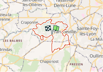
69 Francheville cimetière

trietsch
User

Length
15.8 km

Max alt
314 m

Uphill gradient
297 m
Km-Effort
19.7 km

Min alt
188 m

Downhill gradient
296 m
Boucle
Yes
Creation date :
2021-04-03 19:33:46.367
Updated on :
2021-04-03 19:34:12.458
4h28
Difficulty : Very difficult

FREE GPS app for hiking
 SityTrail
IGN / Geographical institutes
SityTrail Plus
The world is yours!
About
Trail Walking of 15.8 km to be discovered at Auvergne-Rhône-Alpes, Métropole de Lyon, Francheville. This trail is proposed by trietsch.
Positioning
Country:
France
Region :
Auvergne-Rhône-Alpes
Department/Province :
Métropole de Lyon
Municipality :
Francheville
Location:
Unknown
Start:(Dec)
Start:(UTM)
636220 ; 5065879 (31T) N.
Comments