


Aqueduc de Castries Rando B

ARVIEU
User
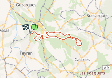

Length
13.9 km

Max alt
116 m

Uphill gradient
163 m
Km-Effort
16.1 km

Min alt
55 m

Downhill gradient
163 m
Boucle
Yes
Creation date :
2021-04-04 11:02:04.896
Updated on :
2021-04-04 11:03:02.035
4h00
Difficulty : Easy

FREE GPS app for hiking
 SityTrail
IGN / Geographical institutes
SityTrail Plus
The world is yours!
About
Trail Walking of 13.9 km to be discovered at Occitania, Hérault, Teyran. This trail is proposed by ARVIEU.
Positioning
Country:
France
Region :
Occitania
Department/Province :
Hérault
Municipality :
Teyran
Location:
Unknown
Start:(Dec)
Start:(UTM)
574906 ; 4838762 (31T) N.
Comments