


caron bagatelle Pâques

gabdudu
User
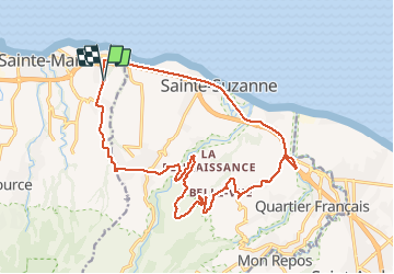

Length
27 km

Max alt
323 m

Uphill gradient
561 m
Km-Effort
35 km

Min alt
3 m

Downhill gradient
561 m
Boucle
Yes
Creation date :
2021-04-04 04:30:34.362
Updated on :
2021-04-04 14:16:15.899
2h14
Difficulty : Difficult

FREE GPS app for hiking
 SityTrail
IGN / Geographical institutes
SityTrail Plus
The world is yours!
About
Trail Mountain bike of 27 km to be discovered at Réunion, Unknown, Sainte-Marie. This trail is proposed by gabdudu.
Description
vtt ango caron bagatelle convenance
Positioning
Country:
France
Region :
Réunion
Department/Province :
Unknown
Municipality :
Sainte-Marie
Location:
Unknown
Start:(Dec)
Start:(UTM)
351297 ; 7687912 (40K) S.
Comments
difficile entre ango et bagatelle