


Orval

Airelle
User

Length
25 km

Max alt
352 m

Uphill gradient
412 m
Km-Effort
31 km

Min alt
184 m

Downhill gradient
411 m
Boucle
Yes
Creation date :
2021-04-04 08:06:24.0
Updated on :
2021-04-10 16:14:18.972
6h30
Difficulty : Unknown

FREE GPS app for hiking
 SityTrail
IGN / Geographical institutes
SityTrail Plus
The world is yours!
About
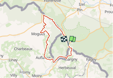
Trail Walking of 25 km to be discovered at Wallonia, Luxembourg, Florenville. This trail is proposed by Airelle.
Description
Attention certains chemins entre les KM 10 et 14 ont disparus et il faut chercher sa trace.
Positioning
Country:
Belgium
Region :
Wallonia
Department/Province :
Luxembourg
Municipality :
Florenville
Location:
Villers-devant-Orval
Start:(Dec)
Start:(UTM)
669313 ; 5500619 (31U) N.
Comments