


Courtonne

aemilon
User
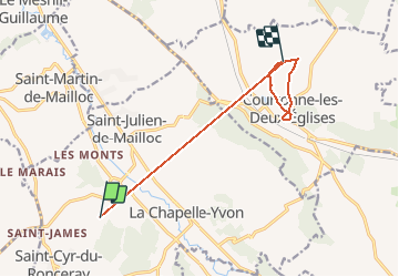

Length
9.2 km

Max alt
178 m

Uphill gradient
283 m
Km-Effort
12.8 km

Min alt
71 m

Downhill gradient
211 m
Boucle
No
Creation date :
2021-04-04 14:24:00.0
Updated on :
2021-04-04 15:28:22.936
1h04
Difficulty : Unknown

FREE GPS app for hiking
 SityTrail
IGN / Geographical institutes
SityTrail Plus
The world is yours!
About
Trail Walking of 9.2 km to be discovered at Normandy, Calvados, Valorbiquet. This trail is proposed by aemilon.
Positioning
Country:
France
Region :
Normandy
Department/Province :
Calvados
Municipality :
Valorbiquet
Location:
Saint-Pierre-de-Mailloc
Start:(Dec)
Start:(UTM)
303630 ; 5438001 (31U) N.
Comments