


Teyran-Castries

ARVIEU
User
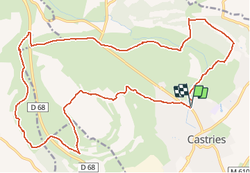

Length
15.2 km

Max alt
104 m

Uphill gradient
148 m
Km-Effort
17.2 km

Min alt
52 m

Downhill gradient
149 m
Boucle
Yes
Creation date :
2021-04-04 16:47:08.225
Updated on :
2021-04-04 16:48:35.704
4h00
Difficulty : Easy

FREE GPS app for hiking
 SityTrail
IGN / Geographical institutes
SityTrail Plus
The world is yours!
About
Trail Walking of 15.2 km to be discovered at Occitania, Hérault, Castries. This trail is proposed by ARVIEU.
Positioning
Country:
France
Region :
Occitania
Department/Province :
Hérault
Municipality :
Castries
Location:
Unknown
Start:(Dec)
Start:(UTM)
579234 ; 4837202 (31T) N.
Comments