


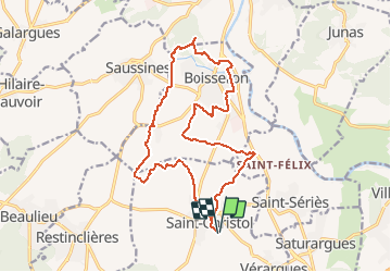
les bois de Boisseron

ARVIEU
User

Length
19 km

Max alt
77 m

Uphill gradient
227 m
Km-Effort
22 km

Min alt
21 m

Downhill gradient
227 m
Boucle
Yes
Creation date :
2021-04-04 17:02:40.392
Updated on :
2021-04-04 17:03:49.333
4h30
Difficulty : Medium

FREE GPS app for hiking
 SityTrail
IGN / Geographical institutes
SityTrail Plus
The world is yours!
About
Trail Walking of 19 km to be discovered at Occitania, Hérault, Entre-Vignes. This trail is proposed by ARVIEU.
Positioning
Country:
France
Region :
Occitania
Department/Province :
Hérault
Municipality :
Entre-Vignes
Location:
Saint-Christol
Start:(Dec)
Start:(UTM)
587192 ; 4841892 (31T) N.
Comments