


Haut de Châtillon sachet

iznogud
User
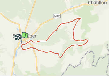

Length
8.1 km

Max alt
390 m

Uphill gradient
185 m
Km-Effort
10.6 km

Min alt
254 m

Downhill gradient
192 m
Boucle
Yes
Creation date :
2021-04-05 09:31:44.0
Updated on :
2021-04-05 10:40:09.657
1h07
Difficulty : Unknown

FREE GPS app for hiking
 SityTrail
IGN / Geographical institutes
SityTrail Plus
The world is yours!
About
Trail Running of 8.1 km to be discovered at Wallonia, Luxembourg, Saint-Léger. This trail is proposed by iznogud.
Description
Solide dénivelé
Positioning
Country:
Belgium
Region :
Wallonia
Department/Province :
Luxembourg
Municipality :
Saint-Léger
Location:
Saint-Léger
Start:(Dec)
Start:(UTM)
691787 ; 5498774 (31U) N.
Comments