


fontes Miramonte benitiers

elexine23
User
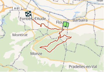

Length
15.8 km

Max alt
386 m

Uphill gradient
604 m
Km-Effort
24 km

Min alt
93 m

Downhill gradient
578 m
Boucle
No
Creation date :
2021-04-05 09:32:57.571
Updated on :
2021-04-05 14:58:31.781
4h51
Difficulty : Medium

FREE GPS app for hiking
 SityTrail
IGN / Geographical institutes
SityTrail Plus
The world is yours!
About
Trail Walking of 15.8 km to be discovered at Occitania, Aude, Floure. This trail is proposed by elexine23.
Description
Partir du début de la rando et pas de fonties
Positioning
Country:
France
Region :
Occitania
Department/Province :
Aude
Municipality :
Floure
Location:
Unknown
Start:(Dec)
Start:(UTM)
458496 ; 4780500 (31T) N.
Comments