


Gr412+129

mozzipsc
User
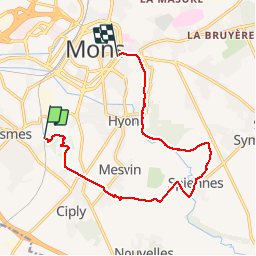

Length
11.8 km

Max alt
119 m

Uphill gradient
160 m
Km-Effort
13.9 km

Min alt
34 m

Downhill gradient
159 m
Boucle
No
Creation date :
2014-12-10 00:00:00.0
Updated on :
2014-12-10 00:00:00.0
3h01
Difficulty : Easy

FREE GPS app for hiking
 SityTrail
IGN / Geographical institutes
SityTrail Plus
The world is yours!
About
Trail Walking of 11.8 km to be discovered at Wallonia, Hainaut, Mons. This trail is proposed by mozzipsc.
Description
Du terril de l'Heribus à Mons par le GR412 et GR129
Photos


Positioning
Country:
Belgium
Region :
Wallonia
Department/Province :
Hainaut
Municipality :
Mons
Location:
Cuesmes
Start:(Dec)
Start:(UTM)
566396 ; 5587433 (31U) N.
Comments