


beausoleil armistice soufriere refuge

sameja
User
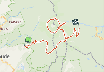

Length
12.5 km

Max alt
1386 m

Uphill gradient
1228 m
Km-Effort
29 km

Min alt
756 m

Downhill gradient
1147 m
Boucle
No
Creation date :
2021-04-08 03:50:11.635
Updated on :
2021-04-08 03:53:40.088
6h30
Difficulty : Very difficult

FREE GPS app for hiking
 SityTrail
IGN / Geographical institutes
SityTrail Plus
The world is yours!
About
Trail Walking of 12.5 km to be discovered at Guadeloupe, Unknown, Saint-Claude. This trail is proposed by sameja.
Positioning
Country:
France
Region :
Guadeloupe
Department/Province :
Unknown
Municipality :
Saint-Claude
Location:
Unknown
Start:(Dec)
Start:(UTM)
641140 ; 1772850 (20Q) N.
Comments