


3 BECS

nordan
User
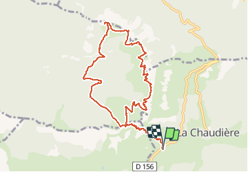

Length
11.2 km

Max alt
1572 m

Uphill gradient
863 m
Km-Effort
23 km

Min alt
1021 m

Downhill gradient
859 m
Boucle
Yes
Creation date :
2021-04-02 08:12:57.244
Updated on :
2021-05-02 15:10:46.525
6h26
Difficulty : Very easy

FREE GPS app for hiking
 SityTrail
IGN / Geographical institutes
SityTrail Plus
The world is yours!
About
Trail Walking of 11.2 km to be discovered at Auvergne-Rhône-Alpes, Drôme, La Chaudière. This trail is proposed by nordan.
Positioning
Country:
France
Region :
Auvergne-Rhône-Alpes
Department/Province :
Drôme
Municipality :
La Chaudière
Location:
Unknown
Start:(Dec)
Start:(UTM)
674877 ; 4944113 (31T) N.
Comments