


Venelles 10,4 km

mhetpierre
User
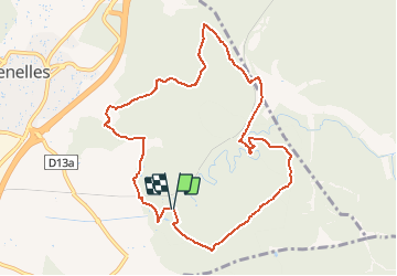

Length
10.4 km

Max alt
421 m

Uphill gradient
215 m
Km-Effort
13.2 km

Min alt
293 m

Downhill gradient
214 m
Boucle
Yes
Creation date :
2021-04-08 09:27:45.393
Updated on :
2021-04-08 09:33:03.194
3h00
Difficulty : Easy

FREE GPS app for hiking
 SityTrail
IGN / Geographical institutes
SityTrail Plus
The world is yours!
About
Trail On foot of 10.4 km to be discovered at Provence-Alpes-Côte d'Azur, Bouches-du-Rhône, Venelles. This trail is proposed by mhetpierre.
Positioning
Country:
France
Region :
Provence-Alpes-Côte d'Azur
Department/Province :
Bouches-du-Rhône
Municipality :
Venelles
Location:
Unknown
Start:(Dec)
Start:(UTM)
702222 ; 4828801 (31T) N.
Comments