


Roche Rousse et Rocher de l'aigle à Guillestre

Sorriaux
User
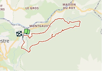

Length
8.6 km

Max alt
1492 m

Uphill gradient
403 m
Km-Effort
14 km

Min alt
1121 m

Downhill gradient
406 m
Boucle
Yes
Creation date :
2021-04-08 07:31:30.859
Updated on :
2021-04-08 12:38:00.764
2h52
Difficulty : Medium

FREE GPS app for hiking
 SityTrail
IGN / Geographical institutes
SityTrail Plus
The world is yours!
About
Trail Walking of 8.6 km to be discovered at Provence-Alpes-Côte d'Azur, Hautes-Alpes, Guillestre. This trail is proposed by Sorriaux.
Description
belle balade pas trop de difficulté
Photos


Positioning
Country:
France
Region :
Provence-Alpes-Côte d'Azur
Department/Province :
Hautes-Alpes
Municipality :
Guillestre
Location:
Unknown
Start:(Dec)
Start:(UTM)
314875 ; 4948158 (32T) N.
Comments