


varayon

vincente204
User
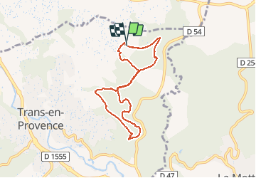

Length
7.5 km

Max alt
232 m

Uphill gradient
192 m
Km-Effort
10.1 km

Min alt
120 m

Downhill gradient
186 m
Boucle
Yes
Creation date :
2021-04-09 11:40:26.065
Updated on :
2021-04-09 13:52:42.241
2h11
Difficulty : Medium

FREE GPS app for hiking
 SityTrail
IGN / Geographical institutes
SityTrail Plus
The world is yours!
About
Trail Walking of 7.5 km to be discovered at Provence-Alpes-Côte d'Azur, Var, Trans-en-Provence. This trail is proposed by vincente204.
Description
facile
Positioning
Country:
France
Region :
Provence-Alpes-Côte d'Azur
Department/Province :
Var
Municipality :
Trans-en-Provence
Location:
Unknown
Start:(Dec)
Start:(UTM)
298547 ; 4821228 (32T) N.
Comments