


mont gedry et voie verte

PatriceCocuaud
User
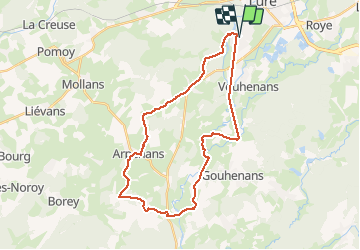

Length
30 km

Max alt
397 m

Uphill gradient
381 m
Km-Effort
35 km

Min alt
263 m

Downhill gradient
381 m
Boucle
Yes
Creation date :
2021-04-10 08:21:19.82
Updated on :
2021-04-10 11:05:53.27
2h44
Difficulty : Easy

FREE GPS app for hiking
 SityTrail
IGN / Geographical institutes
SityTrail Plus
The world is yours!
About
Trail Mountain bike of 30 km to be discovered at Bourgogne-Franche-Comté, Haute-Saône, Magny-Vernois. This trail is proposed by PatriceCocuaud.
Positioning
Country:
France
Region :
Bourgogne-Franche-Comté
Department/Province :
Haute-Saône
Municipality :
Magny-Vernois
Location:
Unknown
Start:(Dec)
Start:(UTM)
310714 ; 5282664 (32T) N.
Comments