


68.604 Berlaar - Bevel

ADL339
User
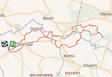

Length
22 km

Max alt
19 m

Uphill gradient
120 m
Km-Effort
24 km

Min alt
1 m

Downhill gradient
120 m
Boucle
Yes
Creation date :
2021-04-10 13:41:20.0
Updated on :
2021-04-10 13:42:00.471
5h25
Difficulty : Medium

FREE GPS app for hiking
 SityTrail
IGN / Geographical institutes
SityTrail Plus
The world is yours!
About
Trail Walking of 22 km to be discovered at Flanders, Antwerp, Berlaar. This trail is proposed by ADL339.
Positioning
Country:
Belgium
Region :
Flanders
Department/Province :
Antwerp
Municipality :
Berlaar
Location:
Berlaar
Start:(Dec)
Start:(UTM)
614771 ; 5663692 (31U) N.
Comments