


Aix - Le Tholonet

ARPF
User
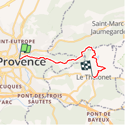

Length
8 km

Max alt
354 m

Uphill gradient
243 m
Km-Effort
11.3 km

Min alt
182 m

Downhill gradient
270 m
Boucle
No
Creation date :
2014-12-10 00:00:00.0
Updated on :
2014-12-10 00:00:00.0
2h24
Difficulty : Easy

FREE GPS app for hiking
 SityTrail
IGN / Geographical institutes
SityTrail Plus
The world is yours!
About
Trail Walking of 8 km to be discovered at Provence-Alpes-Côte d'Azur, Bouches-du-Rhône, Aix-en-Provence. This trail is proposed by ARPF.
Description
P1 T1 Michel 7/8/14
Positioning
Country:
France
Region :
Provence-Alpes-Côte d'Azur
Department/Province :
Bouches-du-Rhône
Municipality :
Aix-en-Provence
Location:
Unknown
Start:(Dec)
Start:(UTM)
698739 ; 4822719 (31T) N.
Comments