


le 12 avril 2021 avec Nicole

FOUCAULT
User

Length
9.5 km

Max alt
110 m

Uphill gradient
130 m
Km-Effort
11.2 km

Min alt
51 m

Downhill gradient
126 m
Boucle
Yes
Creation date :
2021-04-12 12:41:14.916
Updated on :
2021-04-12 15:56:43.416
3h14
Difficulty : Medium

FREE GPS app for hiking
 SityTrail
IGN / Geographical institutes
SityTrail Plus
The world is yours!
About
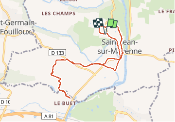
Trail Walking of 9.5 km to be discovered at Pays de la Loire, Mayenne, Saint-Jean-sur-Mayenne. This trail is proposed by FOUCAULT.
Description
facile
Positioning
Country:
France
Region :
Pays de la Loire
Department/Province :
Mayenne
Municipality :
Saint-Jean-sur-Mayenne
Location:
Unknown
Start:(Dec)
Start:(UTM)
666875 ; 5333696 (30U) N.
Comments