


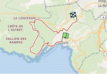
Trail(13) - Cassis - Calanque 1

HG74250
User

Length
14.7 km

Max alt
259 m

Uphill gradient
521 m
Km-Effort
21 km

Min alt
4 m

Downhill gradient
406 m
Boucle
No
Creation date :
2021-04-13 07:32:11.948
Updated on :
2021-04-15 09:50:11.598
2h15
Difficulty : Medium

FREE GPS app for hiking
 SityTrail
IGN / Geographical institutes
SityTrail Plus
The world is yours!
About
Trail Trail of 14.7 km to be discovered at Provence-Alpes-Côte d'Azur, Bouches-du-Rhône, Cassis. This trail is proposed by HG74250.
Description
Départ du Centre de Cassis pour une arrivée à la Gare.
Positioning
Country:
France
Region :
Provence-Alpes-Côte d'Azur
Department/Province :
Bouches-du-Rhône
Municipality :
Cassis
Location:
Unknown
Start:(Dec)
Start:(UTM)
706149 ; 4787741 (31T) N.
Comments