


roc negro

Mascart
User
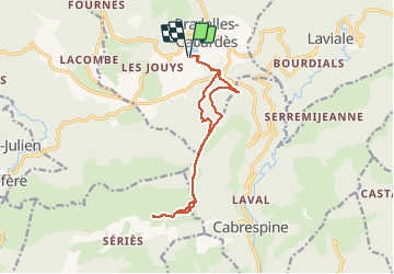

Length
14.2 km

Max alt
911 m

Uphill gradient
365 m
Km-Effort
19.1 km

Min alt
725 m

Downhill gradient
359 m
Boucle
Yes
Creation date :
2021-04-02 08:07:54.948
Updated on :
2021-04-14 11:25:09.018
4h25
Difficulty : Medium

FREE GPS app for hiking
 SityTrail
IGN / Geographical institutes
SityTrail Plus
The world is yours!
About
Trail Walking of 14.2 km to be discovered at Occitania, Aude, Pradelles-Cabardès. This trail is proposed by Mascart.
Description
ok lac de Pradelles
Positioning
Country:
France
Region :
Occitania
Department/Province :
Aude
Municipality :
Pradelles-Cabardès
Location:
Unknown
Start:(Dec)
Start:(UTM)
454717 ; 4805602 (31T) N.
Comments