


Conques-Les Capitelles

dufland
User
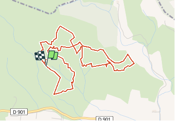

Length
6.4 km

Max alt
248 m

Uphill gradient
94 m
Km-Effort
7.7 km

Min alt
189 m

Downhill gradient
99 m
Boucle
Yes
Creation date :
2021-04-14 20:29:35.611
Updated on :
2021-04-15 15:03:28.784
2h30
Difficulty : Easy

FREE GPS app for hiking
 SityTrail
IGN / Geographical institutes
SityTrail Plus
The world is yours!
About
Trail On foot of 6.4 km to be discovered at Occitania, Aude, Conques-sur-Orbiel. This trail is proposed by dufland.
Description
Cumul des 3 circuits bleu, vert, rose,
Positioning
Country:
France
Region :
Occitania
Department/Province :
Aude
Municipality :
Conques-sur-Orbiel
Location:
Unknown
Start:(Dec)
Start:(UTM)
448977 ; 4793503 (31T) N.
Comments
très agréable