


14042021 16h M

aderas
User

Length
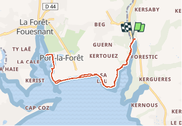
8.7 km

Max alt
26 m

Uphill gradient
84 m
Km-Effort
9.8 km

Min alt
0 m

Downhill gradient
84 m
Boucle
Yes
Creation date :
2021-04-14 13:04:09.995
Updated on :
2021-04-15 13:57:49.832
1h58
Difficulty : Medium

FREE GPS app for hiking
 SityTrail
IGN / Geographical institutes
SityTrail Plus
The world is yours!
About
Trail Walking of 8.7 km to be discovered at Brittany, Finistère, Concarneau. This trail is proposed by aderas.
Positioning
Country:
France
Region :
Brittany
Department/Province :
Finistère
Municipality :
Concarneau
Location:
Unknown
Start:(Dec)
Start:(UTM)
429287 ; 5306224 (30T) N.
Comments