


Eaunes lèze fait

pidjam
User
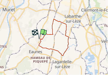

Length
11.3 km

Max alt
212 m

Uphill gradient
83 m
Km-Effort
12.4 km

Min alt
166 m

Downhill gradient
82 m
Boucle
Yes
Creation date :
2021-04-15 11:54:53.28
Updated on :
2021-04-16 07:01:32.38
2h36
Difficulty : Easy

FREE GPS app for hiking
 SityTrail
IGN / Geographical institutes
SityTrail Plus
The world is yours!
About
Trail Walking of 11.3 km to be discovered at Occitania, Haute-Garonne, Eaunes. This trail is proposed by pidjam.
Description
La partie à partir du km 1 est plutôt sauvage (prévoir un sécateur?) mais on peut la remplacer par la route; ça ferait beaucoup de route au total.
Positioning
Country:
France
Region :
Occitania
Department/Province :
Haute-Garonne
Municipality :
Eaunes
Location:
Unknown
Start:(Dec)
Start:(UTM)
367396 ; 4810484 (31T) N.
Comments