


2014-05-07_Fontaines

jcm17
User
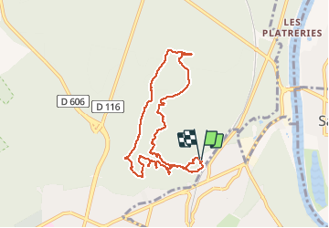

Length
8.7 km

Max alt
158 m

Uphill gradient
167 m
Km-Effort
10.9 km

Min alt
88 m

Downhill gradient
162 m
Boucle
Yes
Creation date :
2014-12-10 00:00:00.0
Updated on :
2014-12-10 00:00:00.0
3h07
Difficulty : Medium

FREE GPS app for hiking
 SityTrail
IGN / Geographical institutes
SityTrail Plus
The world is yours!
About
Trail Walking of 8.7 km to be discovered at Ile-de-France, Seine-et-Marne, Fontainebleau. This trail is proposed by jcm17.
Description
Sortie GLM
circuit des Fontaines et dezs Points de vue entre la Croix du Calvaire et la Tour Denécourt
Départ de la station de Biologie.
Positioning
Country:
France
Region :
Ile-de-France
Department/Province :
Seine-et-Marne
Municipality :
Fontainebleau
Location:
Unknown
Start:(Dec)
Start:(UTM)
479873 ; 5363096 (31U) N.
Comments