


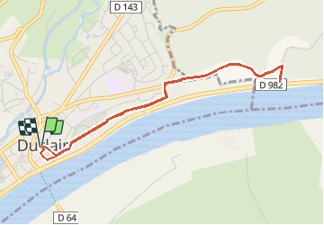
Les hauteurs de Duclair

JMCMoreau
User

Length
4.3 km

Max alt
51 m

Uphill gradient
104 m
Km-Effort
5.7 km

Min alt
7 m

Downhill gradient
104 m
Boucle
Yes
Creation date :
2021-04-16 07:50:54.155
Updated on :
2021-04-16 07:53:15.766
2h30
Difficulty : Easy

FREE GPS app for hiking
 SityTrail
IGN / Geographical institutes
SityTrail Plus
The world is yours!
About
Trail Walking of 4.3 km to be discovered at Normandy, Seine-Maritime, Duclair. This trail is proposed by JMCMoreau.
Description
Petite balade pour les Bibous.
Sans difficulté
Variée
Beaux paysages sur la Vallée de la Seine
Positioning
Country:
France
Region :
Normandy
Department/Province :
Seine-Maritime
Municipality :
Duclair
Location:
Unknown
Start:(Dec)
Start:(UTM)
346120 ; 5483264 (31U) N.
Comments