


Melin Sclinpre Wahenge

emoreau
User
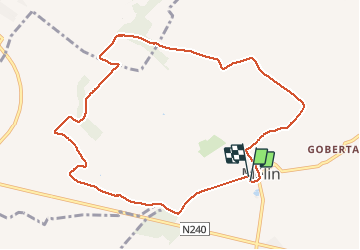

Length
9.3 km

Max alt
134 m

Uphill gradient
104 m
Km-Effort
10.7 km

Min alt
89 m

Downhill gradient
102 m
Boucle
Yes
Creation date :
2021-04-16 11:10:10.224
Updated on :
2021-04-16 13:27:38.252
2h16
Difficulty : Medium

FREE GPS app for hiking
 SityTrail
IGN / Geographical institutes
SityTrail Plus
The world is yours!
About
Trail Walking of 9.3 km to be discovered at Wallonia, Walloon Brabant, Jodoigne. This trail is proposed by emoreau.
Positioning
Country:
Belgium
Region :
Wallonia
Department/Province :
Walloon Brabant
Municipality :
Jodoigne
Location:
Mélin
Start:(Dec)
Start:(UTM)
628897 ; 5622435 (31U) N.
Comments