


Course 16 avril

Damien1271
User

Length
9.7 km

Max alt
269 m

Uphill gradient
250 m
Km-Effort
13 km

Min alt
134 m

Downhill gradient
254 m
Boucle
Yes
Creation date :
2021-04-16 12:30:56.0
Updated on :
2021-04-16 13:30:28.751
59m
Difficulty : Unknown

FREE GPS app for hiking
 SityTrail
IGN / Geographical institutes
SityTrail Plus
The world is yours!
About
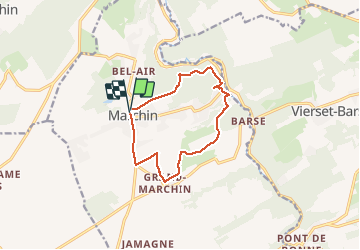
Trail Trail of 9.7 km to be discovered at Wallonia, Liège, Marchin. This trail is proposed by Damien1271.
Positioning
Country:
Belgium
Region :
Wallonia
Department/Province :
Liège
Municipality :
Marchin
Location:
Marchin
Start:(Dec)
Start:(UTM)
657907 ; 5594508 (31U) N.
Comments