


Natation Port Cassis - Entrée de Port-Miou

HG74250
User

Length
2 km

Max alt
18 m

Uphill gradient
28 m
Km-Effort
2.4 km

Min alt
-1 m

Downhill gradient
35 m
Boucle
No
Creation date :
2021-04-16 17:30:00.726
Updated on :
2021-04-16 17:37:57.274
1h00
Difficulty : Medium

FREE GPS app for hiking
 SityTrail
IGN / Geographical institutes
SityTrail Plus
The world is yours!
About
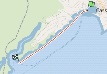
Trail Swimming of 2 km to be discovered at Provence-Alpes-Côte d'Azur, Bouches-du-Rhône, Cassis. This trail is proposed by HG74250.
Description
Plage-Bleue 1,7 km
Positioning
Country:
France
Region :
Provence-Alpes-Côte d'Azur
Department/Province :
Bouches-du-Rhône
Municipality :
Cassis
Location:
Unknown
Start:(Dec)
Start:(UTM)
705911 ; 4787693 (31T) N.
Comments