


2021-04-16 16:42:06

mitch1952
User
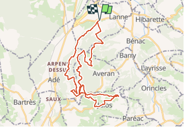

Length
21 km

Max alt
643 m

Uphill gradient
649 m
Km-Effort
30 km

Min alt
377 m

Downhill gradient
649 m
Boucle
Yes
Creation date :
2021-04-16 17:46:35.74
Updated on :
2022-06-08 13:12:41.434
6h48
Difficulty : Medium

FREE GPS app for hiking
 SityTrail
IGN / Geographical institutes
SityTrail Plus
The world is yours!
About
Trail On foot of 21 km to be discovered at Occitania, Hautespyrenees, Lanne. This trail is proposed by mitch1952.
Description
IBP index 85 : dénivelée à partir IBP 785 m
Positioning
Country:
France
Region :
Occitania
Department/Province :
Hautespyrenees
Municipality :
Lanne
Location:
Unknown
Start:(Dec)
Start:(UTM)
256313 ; 4783354 (31T) N.
Comments