


2021-04-17 Forêt de Taverny

Bernardb44
User
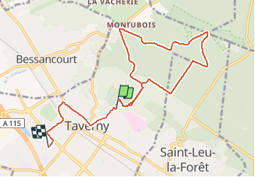

Length
9.5 km

Max alt
194 m

Uphill gradient
121 m
Km-Effort
11.4 km

Min alt
77 m

Downhill gradient
186 m
Boucle
No
Creation date :
2021-04-17 13:34:47.176
Updated on :
2021-04-17 15:19:46.051
1h44
Difficulty : Easy

FREE GPS app for hiking
 SityTrail
IGN / Geographical institutes
SityTrail Plus
The world is yours!
About
Trail Walking of 9.5 km to be discovered at Ile-de-France, Val-d'Oise, Taverny. This trail is proposed by Bernardb44.
Positioning
Country:
France
Region :
Ile-de-France
Department/Province :
Val-d'Oise
Municipality :
Taverny
Location:
Unknown
Start:(Dec)
Start:(UTM)
443764 ; 5431002 (31U) N.
Comments