


11 o4 2021

gillescailloz
User

Length
48 km

Max alt
334 m

Uphill gradient
749 m
Km-Effort
58 km

Min alt
203 m

Downhill gradient
749 m
Boucle
Yes
Creation date :
2021-04-11 06:06:35.879
Updated on :
2021-04-17 18:05:03.706
3h47
Difficulty : Medium

FREE GPS app for hiking
 SityTrail
IGN / Geographical institutes
SityTrail Plus
The world is yours!
About
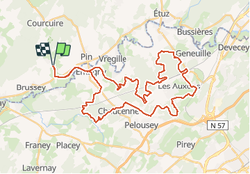
Trail Mountain bike of 48 km to be discovered at Bourgogne-Franche-Comté, Haute-Saône, Beaumotte-lès-Pin. This trail is proposed by gillescailloz.
Positioning
Country:
France
Region :
Bourgogne-Franche-Comté
Department/Province :
Haute-Saône
Municipality :
Beaumotte-lès-Pin
Location:
Unknown
Start:(Dec)
Start:(UTM)
714086 ; 5244043 (31T) N.
Comments