


Pont du Countet - Refuge de Nice 26 07 2020

Hugues Michel
User
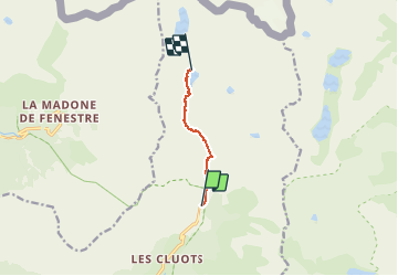

Length
5.4 km

Max alt
2217 m

Uphill gradient
526 m
Km-Effort
10.8 km

Min alt
1686 m

Downhill gradient
19 m
Boucle
No
Creation date :
2021-04-17 20:12:11.436
Updated on :
2021-04-17 20:12:11.436
--
Difficulty : Unknown

FREE GPS app for hiking
 SityTrail
IGN / Geographical institutes
SityTrail Plus
The world is yours!
About
Trail Walking of 5.4 km to be discovered at Provence-Alpes-Côte d'Azur, Maritime Alps, Belvédère. This trail is proposed by Hugues Michel.
Positioning
Country:
France
Region :
Provence-Alpes-Côte d'Azur
Department/Province :
Maritime Alps
Municipality :
Belvédère
Location:
Unknown
Start:(Dec)
Start:(UTM)
371917 ; 4881373 (32T) N.
Comments