


logette
User
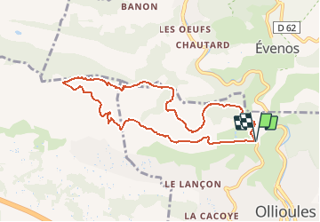

Length
9.3 km

Max alt
433 m

Uphill gradient
368 m
Km-Effort
14.2 km

Min alt
151 m

Downhill gradient
368 m
Boucle
Yes
Creation date :
2021-04-18 08:05:07.973
Updated on :
2021-04-18 08:13:51.902

FREE GPS app for hiking
 SityTrail
IGN / Geographical institutes
SityTrail Plus
The world is yours!
About
Trail of 9.3 km to be discovered at Provence-Alpes-Côte d'Azur, Var, Ollioules. This trail is proposed by logette.
Positioning
Country:
France
Region :
Provence-Alpes-Côte d'Azur
Department/Province :
Var
Municipality :
Ollioules
Location:
Unknown
Start:(Dec)
Start:(UTM)
731141 ; 4781354 (31T) N.
Comments