


BM-04-03-2021 rando du 18.04.2021

bene_dictus77
User
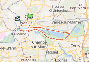

Length
12.9 km

Max alt
46 m

Uphill gradient
59 m
Km-Effort
13.7 km

Min alt
35 m

Downhill gradient
61 m
Boucle
No
Creation date :
2021-04-18 07:16:21.691
Updated on :
2021-04-18 11:05:00.353
3h46
Difficulty : Very easy

FREE GPS app for hiking
 SityTrail
IGN / Geographical institutes
SityTrail Plus
The world is yours!
About
Trail Walking of 12.9 km to be discovered at Ile-de-France, Seine-et-Marne, Chelles. This trail is proposed by bene_dictus77.
Description
Autour du lac de Vaires
Positioning
Country:
France
Region :
Ile-de-France
Department/Province :
Seine-et-Marne
Municipality :
Chelles
Location:
Unknown
Start:(Dec)
Start:(UTM)
469594 ; 5413479 (31U) N.
Comments