


Tour de la madone

Arnaud Stévenard
User
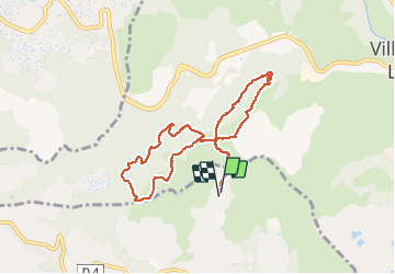

Length
9.4 km

Max alt
175 m

Uphill gradient
263 m
Km-Effort
12.9 km

Min alt
49 m

Downhill gradient
266 m
Boucle
Yes
Creation date :
2021-04-18 06:56:00.0
Updated on :
2021-04-18 11:45:46.852
4h30
Difficulty : Very easy

FREE GPS app for hiking
 SityTrail
IGN / Geographical institutes
SityTrail Plus
The world is yours!
About
Trail Walking of 9.4 km to be discovered at Provence-Alpes-Côte d'Azur, Maritime Alps, Biot. This trail is proposed by Arnaud Stévenard.
Positioning
Country:
France
Region :
Provence-Alpes-Côte d'Azur
Department/Province :
Maritime Alps
Municipality :
Biot
Location:
Unknown
Start:(Dec)
Start:(UTM)
346034 ; 4833989 (32T) N.
Comments