


Ludres plateau les roches

Marin B
User
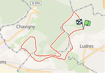

Length
11.5 km

Max alt
423 m

Uphill gradient
233 m
Km-Effort
14.6 km

Min alt
320 m

Downhill gradient
230 m
Boucle
Yes
Creation date :
2021-04-18 11:51:18.277
Updated on :
2021-04-18 14:45:08.216
2h52
Difficulty : Medium

FREE GPS app for hiking
 SityTrail
IGN / Geographical institutes
SityTrail Plus
The world is yours!
About
Trail Walking of 11.5 km to be discovered at Grand Est, Meurthe-et-Moselle, Ludres. This trail is proposed by Marin B.
Positioning
Country:
France
Region :
Grand Est
Department/Province :
Meurthe-et-Moselle
Municipality :
Ludres
Location:
Unknown
Start:(Dec)
Start:(UTM)
290674 ; 5390020 (32U) N.
Comments