


becquet

AMOURETTE
User

Length
10.9 km

Max alt
95 m

Uphill gradient
161 m
Km-Effort
13 km

Min alt
-1 m

Downhill gradient
161 m
Boucle
Yes
Creation date :
2021-04-18 12:04:02.539
Updated on :
2021-04-18 15:23:20.661
2h48
Difficulty : Difficult

FREE GPS app for hiking
 SityTrail
IGN / Geographical institutes
SityTrail Plus
The world is yours!
About
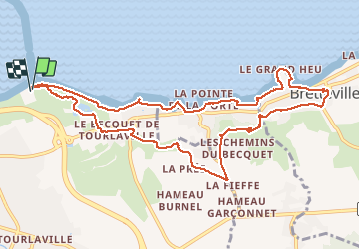
Trail Walking of 10.9 km to be discovered at Normandy, Manche, Cherbourg-en-Cotentin. This trail is proposed by AMOURETTE.
Positioning
Country:
France
Region :
Normandy
Department/Province :
Manche
Municipality :
Cherbourg-en-Cotentin
Location:
Tourlaville
Start:(Dec)
Start:(UTM)
603198 ; 5501382 (30U) N.
Comments