


Le Faron

soca
User
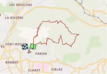

Length
9.7 km

Max alt
533 m

Uphill gradient
592 m
Km-Effort
17.6 km

Min alt
130 m

Downhill gradient
595 m
Boucle
Yes
Creation date :
2021-04-19 22:02:29.787
Updated on :
2021-04-19 22:04:26.811
5h00
Difficulty : Difficult

FREE GPS app for hiking
 SityTrail
IGN / Geographical institutes
SityTrail Plus
The world is yours!
About
Trail Walking of 9.7 km to be discovered at Provence-Alpes-Côte d'Azur, Var, Toulon. This trail is proposed by soca.
Positioning
Country:
France
Region :
Provence-Alpes-Côte d'Azur
Department/Province :
Var
Municipality :
Toulon
Location:
Unknown
Start:(Dec)
Start:(UTM)
737832 ; 4780442 (31T) N.
Comments