


Lurany marcilly via saone azergues

ophness
User
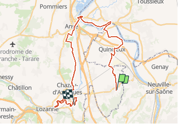

Length
34 km

Max alt
277 m

Uphill gradient
323 m
Km-Effort
39 km

Min alt
165 m

Downhill gradient
296 m
Boucle
No
Creation date :
2021-04-20 10:02:05.949
Updated on :
2021-04-26 06:40:11.697
5h00
Difficulty : Difficult

FREE GPS app for hiking
 SityTrail
IGN / Geographical institutes
SityTrail Plus
The world is yours!
About
Trail Horseback riding of 34 km to be discovered at Auvergne-Rhône-Alpes, Rhône, Chasselay. This trail is proposed by ophness.
Positioning
Country:
France
Region :
Auvergne-Rhône-Alpes
Department/Province :
Rhône
Municipality :
Chasselay
Location:
Unknown
Start:(Dec)
Start:(UTM)
638210 ; 5081652 (31T) N.
Comments