Trail Mountain bike Mersuay - le chaumont - Photo
© OpenStreetMap contributors
Length
Length
26 km
Max alt
Max alt
413 m
Uphill gradient
Uphill gradient
330 m
Km-Effort
Km-Effort  
30 km
Min alt
Min alt
212 m
Downhill gradient
Downhill gradient
330 m
Boucle
Boucle
Yes
Creation date :
2021-04-20 08:19:14.931
Updated on :
2021-04-20 13:46:38.233

(0 Reviews)

Mountain bike
Mountain bike
5h25
Difficulty : Medium
Hybrid bike
Hybrid bike
5h24
Difficulty : Medium

Scan this QR Code to open this trail in the SityTrail application

FREE GPS app for hiking

Logo SityTrail SityTrail

IGN / Geographical institutes

Download SityTrail from the App Store Download SityTrail from Google Play

Logo SityTrail SityTrail World

The world is yours!

Download SityTrail from the App Store Download SityTrail from Google Play Download SityTrail on Huawei AppGallery

About

Trail Mountain bike of 26 km to be discovered at Bourgogne-Franche-Comté, Haute-Saône, Mersuay. This trail is proposed by annamaria.

Description

Agreable rando avec des enfants. Tres jolie vue depuis la petite chapelle de la banie.

Elevation profile

Positioning

Country:
France
Region :
Bourgogne-Franche-Comté
Department/Province :
Haute-Saône
Municipality :
Mersuay
Location:
Unknown
Start:(UTM)
285623 ; 5295934 (32T) N.

Trails nearby

Trail Walking Faverney - j)Etapa 10 - Photo
Walking
RafaTuareg

Walking

Medium
Faverney, Bourgogne-Franche-Comté, Haute-Saône, France
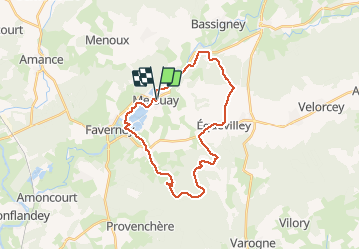
31 km | 36 km-effort
7h 54min
No
Trail Mountain bike Breurey-lès-Faverney - De Breurey lès Faverney à Vignieu en VTT- Étape 1/6 - Photo
Mountain bike
tracegps

Mountain bike

Difficult
Breurey-lès-Faverney, Bourgogne-Franche-Comté, Haute-Saône, France
74 km | 90 km-effort
8h 0min
No
Trail Walking Neurey-en-Vaux - Autour de Neurey en vaux ( idéal en été )  - Photo
Walking
nicolasdresse

Walking

Medium
Neurey-en-Vaux, Bourgogne-Franche-Comté, Haute-Saône, France
7.6 km | 9.8 km-effort
1h 53min
Yes
Trail Cycle Mersuay - Mersuay - Autrey le Vay -  v2 - Photo
Cycle
Pierrannick

Cycle

Very easy
Mersuay, Bourgogne-Franche-Comté, Haute-Saône, France
48 km | 55 km-effort
Unknown
No
Trail Walking Le Val-Saint-Éloi - Le chaumont  - Photo
Walking
normandb

Walking

Very easy
Le Val-Saint-Éloi, Bourgogne-Franche-Comté, Haute-Saône, France
9.2 km | 12 km-effort
2h 44min
Yes
Trail Walking Neurey-en-Vaux - de Neurey en vaux au val saint eloi - Photo
Walking
nicolasdresse

Walking

Very easy
Neurey-en-Vaux, Bourgogne-Franche-Comté, Haute-Saône, France
7.5 km | 9.6 km-effort
1h 58min
Yes


Close
My subscriptions