Trail Walking Précy-sur-Oise - randonnée de precy au bois st Michel - Photo

randonnée de precy au bois st Michel

© OpenStreetMap contributors
Length
Length
11.6 km
Max alt
Max alt
128 m
Uphill gradient
Uphill gradient
199 m
Km-Effort
Km-Effort  
14.2 km
Min alt
Min alt
35 m
Downhill gradient
Downhill gradient
200 m
Boucle
Boucle
Yes
Creation date :
2021-04-21 07:02:50.558
Updated on :
2021-04-21 09:46:55.992

(0 Reviews)

Walking
Walking
2h47
Difficulty : Medium

Scan this QR Code to open this trail in the SityTrail application

FREE GPS app for hiking

Logo SityTrail SityTrail

IGN / Geographical institutes

Download SityTrail from the App Store Download SityTrail from Google Play

Logo SityTrail SityTrail World

The world is yours!

Download SityTrail from the App Store Download SityTrail from Google Play Download SityTrail on Huawei AppGallery

About

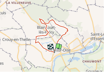
Trail Walking of 11.6 km to be discovered at Hauts-de-France, Oise, Précy-sur-Oise. This trail is proposed by jumetz philippe.

Description

randonnée avec 2 difficultés au début et au milieu de la randonnée

Elevation profile

Photos

Positioning

Country:
France
Region :
Hauts-de-France
Department/Province :
Oise
Municipality :
Précy-sur-Oise
Location:
Unknown
Start:(UTM)
453985 ; 5450376 (31U) N.

Trails nearby

Trail Walking Boran-sur-Oise - randonnée abbaye de Royaumont - Photo
Walking
jumetz philippe

Walking

Difficult
(1)
Boran-sur-Oise, Hauts-de-France, Oise, France
13.2 km | 14.5 km-effort
3h 8min
Yes
Trail Walking Boran-sur-Oise - boran Le Lys - Photo
Walking
avdem

Walking

Very easy
Boran-sur-Oise, Hauts-de-France, Oise, France
11.8 km | 12.8 km-effort
2h 58min
Yes
Trail Walking Boran-sur-Oise - randonnée de precy entre campagne et le long de l oise - Photo
Walking
jumetz philippe

Walking

Easy
Boran-sur-Oise, Hauts-de-France, Oise, France
13.6 km | 15.3 km-effort
3h 19min
Yes
Trail Walking Boran-sur-Oise - randonnée des 3comunnes boran  morangle crouy en thelle - Photo
Walking
jumetz philippe

Walking

Medium
Boran-sur-Oise, Hauts-de-France, Oise, France
17.8 km | 19.8 km-effort
3h 46min
Yes
Trail Walking Saint-Leu-d'Esserent - CRAB : Saint Leu d'Esserent - Photo
Walking
PatRando

Walking

Easy
Saint-Leu-d'Esserent, Hauts-de-France, Oise, France
24 km | 28 km-effort
6h 7min
Yes
Trail Walking Villers-sous-Saint-Leu - THIVERNY_12,6 km_Trace GPS - Photo
Walking
Pousscailleux

Walking

Medium
Villers-sous-Saint-Leu, Hauts-de-France, Oise, France
12.6 km | 14.7 km-effort
2h 56min
Yes
Trail Walking Villers-sous-Saint-Leu - La Rive des Moines - 9,6 km - Photo
Walking
Pousscailleux

Walking

Easy
(1)
Villers-sous-Saint-Leu, Hauts-de-France, Oise, France
9.6 km | 11.3 km-effort
1h 58min
Yes
Trail Walking Boran-sur-Oise - Balingants en bord de l'Oise - Boran-sur-Oise - Photo
Walking
tracegps

Walking

Easy
Boran-sur-Oise, Hauts-de-France, Oise, France
6.1 km | 6.5 km-effort
1h 30min
Yes
Trail Walking Précy-sur-Oise - les maisons troglodytes - Photo
Walking
jumetz philippe

Walking

Medium
Précy-sur-Oise, Hauts-de-France, Oise, France
11.6 km | 13.2 km-effort
2h 33min
Yes


Close
My subscriptions