


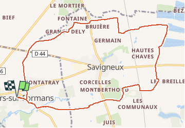
Ars-Sur-Formans (12 km - D. 90 m)

Thomasdanielle
User

Length
12.1 km

Max alt
280 m

Uphill gradient
90 m
Km-Effort
13.3 km

Min alt
234 m

Downhill gradient
90 m
Boucle
Yes
Creation date :
2021-04-21 11:54:40.0
Updated on :
2021-04-22 08:34:31.764
3h19
Difficulty : Easy

FREE GPS app for hiking
 SityTrail
IGN / Geographical institutes
SityTrail Plus
The world is yours!
About
Trail Walking of 12.1 km to be discovered at Auvergne-Rhône-Alpes, Ain, Ars-sur-Formans. This trail is proposed by Thomasdanielle.
Description
D/A : Chemin des mûriers à Ars
En partant d'Ars la marche se fait principalement autour de Savigneux puis retour sur Ars
Positioning
Country:
France
Region :
Auvergne-Rhône-Alpes
Department/Province :
Ain
Municipality :
Ars-sur-Formans
Location:
Unknown
Start:(Dec)
Start:(UTM)
640841 ; 5094953 (31T) N.
Comments