


Le rouret

papajp
User
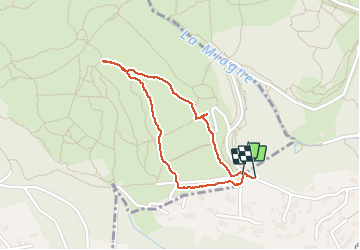

Length
1.7 km

Max alt
390 m

Uphill gradient
18 m
Km-Effort
1.9 km

Min alt
370 m

Downhill gradient
18 m
Boucle
Yes
Creation date :
2021-04-22 13:02:56.0
Updated on :
2021-04-22 14:03:12.677
58m
Difficulty : Easy

FREE GPS app for hiking
 SityTrail
IGN / Geographical institutes
SityTrail Plus
The world is yours!
About
Trail Walking of 1.7 km to be discovered at Provence-Alpes-Côte d'Azur, Maritime Alps, Châteauneuf-Grasse. This trail is proposed by papajp.
Positioning
Country:
France
Region :
Provence-Alpes-Côte d'Azur
Department/Province :
Maritime Alps
Municipality :
Châteauneuf-Grasse
Location:
Unknown
Start:(Dec)
Start:(UTM)
338686 ; 4838042 (32T) N.
Comments