


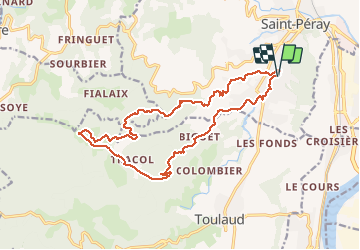
le vallon du jergne

christian4
User

Length
18.9 km

Max alt
508 m

Uphill gradient
630 m
Km-Effort
27 km

Min alt
137 m

Downhill gradient
629 m
Boucle
Yes
Creation date :
2021-04-22 08:06:29.091
Updated on :
2021-04-22 14:21:05.842
4h56
Difficulty : Medium

FREE GPS app for hiking
 SityTrail
IGN / Geographical institutes
SityTrail Plus
The world is yours!
About
Trail Walking of 18.9 km to be discovered at Auvergne-Rhône-Alpes, Ardèche, Saint-Péray. This trail is proposed by christian4.
Description
tres belle rando, un peut de route en fin de parcour.
Positioning
Country:
France
Region :
Auvergne-Rhône-Alpes
Department/Province :
Ardèche
Municipality :
Saint-Péray
Location:
Unknown
Start:(Dec)
Start:(UTM)
644955 ; 4977105 (31T) N.
Comments