


mours

HAL26
User
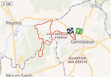

Length
7.8 km

Max alt
321 m

Uphill gradient
216 m
Km-Effort
10.7 km

Min alt
202 m

Downhill gradient
215 m
Boucle
Yes
Creation date :
2021-04-22 12:36:26.333
Updated on :
2021-04-22 14:43:15.711
1h50
Difficulty : Very easy

FREE GPS app for hiking
 SityTrail
IGN / Geographical institutes
SityTrail Plus
The world is yours!
About
Trail Walking of 7.8 km to be discovered at Auvergne-Rhône-Alpes, Drôme, Génissieux. This trail is proposed by HAL26.
Positioning
Country:
France
Region :
Auvergne-Rhône-Alpes
Department/Province :
Drôme
Municipality :
Génissieux
Location:
Unknown
Start:(Dec)
Start:(UTM)
663846 ; 4994632 (31T) N.
Comments