Trail Road bike Cazères - Autour de Cazères - Photo

Autour de Cazères

© OpenStreetMap contributors
Length
Length
81 km
Max alt
Max alt
386 m
Uphill gradient
Uphill gradient
738 m
Km-Effort
Km-Effort  
90 km
Min alt
Min alt
215 m
Downhill gradient
Downhill gradient
739 m
Boucle
Boucle
Yes
Creation date :
2021-04-23 07:15:58.24
Updated on :
2021-04-23 08:17:01.165

(0 Reviews)

Road bike
Road bike
5h21
Difficulty : Very difficult

Scan this QR Code to open this trail in the SityTrail application

FREE GPS app for hiking

Logo SityTrail SityTrail

IGN / Geographical institutes

Download SityTrail from the App Store Download SityTrail from Google Play

Logo SityTrail SityTrail World

The world is yours!

Download SityTrail from the App Store Download SityTrail from Google Play Download SityTrail on Huawei AppGallery

About

Trail Road bike of 81 km to be discovered at Occitania, Haute-Garonne, Cazères. This trail is proposed by Gérard Crespo.

Description

Autour de Cazères covid 10 km

Elevation profile

Positioning

Country:
France
Region :
Occitania
Department/Province :
Haute-Garonne
Municipality :
Cazères
Location:
Unknown
Start:(UTM)
344547 ; 4786818 (31T) N.

Trails nearby

Trail Mountain bike Cazères - Merde - Photo
Mountain bike
Franck Pineau

Mountain bike

Medium
Cazères, Occitania, Haute-Garonne, France
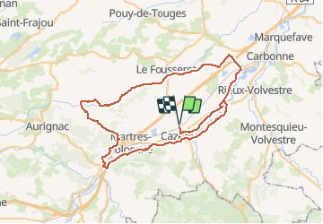
17.3 km | 21 km-effort
1h 39min
Yes
Trail Road bike Cazères - Autour de Cazeres 2 - Photo
Road bike
Gérard Crespo

Road bike

Very difficult
Cazères, Occitania, Haute-Garonne, France
81 km | 91 km-effort
4h 20min
Yes
Trail Walking Saint-Christaud - st christaud- le plan- stchristaud - Photo
Walking
gerard.beyne

Walking

Easy
Saint-Christaud, Occitania, Haute-Garonne, France
7.4 km | 9.7 km-effort
2h 1min
Yes
Trail Mountain bike Palaminy - Petites Pyrénées - Cazères Tounis - Photo
Mountain bike
tracegps

Mountain bike

Difficult
(1)
Palaminy, Occitania, Haute-Garonne, France
24 km | 35 km-effort
2h 30min
Yes
Trail Walking Mauran - 2024-05-26_22h28m39_ Randonnee_n_51502642 - Photo
Walking
pidjam

Walking

Difficult
Mauran, Occitania, Haute-Garonne, France
8.9 km | 13 km-effort
2h 57min
Yes
Trail Walking Saint-Christaud - Gensac fait 2023 - Photo
Walking
pidjam

Walking

Easy
Saint-Christaud, Occitania, Haute-Garonne, France
8.2 km | 0 m-effort
2h 8min
Yes
Trail Walking Saint-Christaud - Alain gensac - Photo
Walking
ClubAgeHeureux

Walking

Medium
Saint-Christaud, Occitania, Haute-Garonne, France
8.3 km | 11.4 km-effort
2h 5min
Yes
Trail Walking Saint-Christaud - 2023-08-31_08h59m57_Gensac-PontDuDiable2 - Photo
Walking
pidjam

Walking

Medium
Saint-Christaud, Occitania, Haute-Garonne, France
8.1 km | 11.1 km-effort
2h 31min
Yes
Trail Mountain bike Cazères - saint girons - Photo
Mountain bike
Patriste

Mountain bike

Easy
Cazères, Occitania, Haute-Garonne, France
60 km | 68 km-effort
4h 53min
No


Close
My subscriptions