


francheville genevieve

maclobar
User
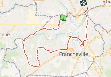

Length
9.8 km

Max alt
308 m

Uphill gradient
152 m
Km-Effort
11.9 km

Min alt
190 m

Downhill gradient
176 m
Boucle
No
Creation date :
2021-04-23 11:36:04.4
Updated on :
2021-04-23 15:37:33.282
2h46
Difficulty : Medium

FREE GPS app for hiking
 SityTrail
IGN / Geographical institutes
SityTrail Plus
The world is yours!
About
Trail Walking of 9.8 km to be discovered at Auvergne-Rhône-Alpes, Métropole de Lyon, Francheville. This trail is proposed by maclobar.
Positioning
Country:
France
Region :
Auvergne-Rhône-Alpes
Department/Province :
Métropole de Lyon
Municipality :
Francheville
Location:
Unknown
Start:(Dec)
Start:(UTM)
636640 ; 5067463 (31T) N.
Comments