


Chartreuse rocher de Chalves

c.gourme
User

Length
16.3 km

Max alt
1840 m

Uphill gradient
1284 m
Km-Effort
33 km

Min alt
754 m

Downhill gradient
1281 m
Boucle
Yes
Creation date :
2021-04-23 06:58:08.0
Updated on :
2021-04-23 15:38:49.203
6h39
Difficulty : Difficult

FREE GPS app for hiking
 SityTrail
IGN / Geographical institutes
SityTrail Plus
The world is yours!
About
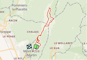
Trail Walking of 16.3 km to be discovered at Auvergne-Rhône-Alpes, Isère, Mont-Saint-Martin. This trail is proposed by c.gourme.
Positioning
Country:
France
Region :
Auvergne-Rhône-Alpes
Department/Province :
Isère
Municipality :
Mont-Saint-Martin
Location:
Unknown
Start:(Dec)
Start:(UTM)
709905 ; 5016694 (31T) N.
Comments