


BM-04-4 du 23.04.2021

bene_dictus77
User

Length
6.3 km

Max alt
52 m

Uphill gradient
38 m
Km-Effort
6.9 km

Min alt
34 m

Downhill gradient
38 m
Boucle
No
Creation date :
2021-04-23 15:32:00.4
Updated on :
2021-04-23 16:48:32.364
1h15
Difficulty : Very easy

FREE GPS app for hiking
 SityTrail
IGN / Geographical institutes
SityTrail Plus
The world is yours!
About
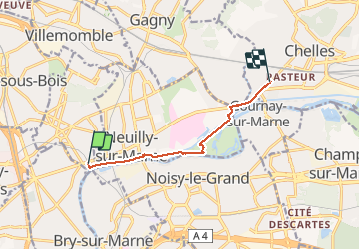
Trail Walking of 6.3 km to be discovered at Ile-de-France, Seine-Saint-Denis, Neuilly-Plaisance. This trail is proposed by bene_dictus77.
Description
De Neuilly Plaisance RER à Chelles
Positioning
Country:
France
Region :
Ile-de-France
Department/Province :
Seine-Saint-Denis
Municipality :
Neuilly-Plaisance
Location:
Unknown
Start:(Dec)
Start:(UTM)
464385 ; 5411185 (31U) N.
Comments